Get Out There and Explore!
The Sacramento NWR Complex offers many opportunities to get outside and explore:
Auto Tours, Trails, Bicycling
Visit Us <-- for everything else, see our Visit Us page!
_____________________________________________________
AUTO TOURS
The Sacramento NWR Complex has 2 different Auto Tours (Sacramento NWR and Colusa NWR) that offer up spectacular wildlife viewing during the winter months.
Visitors must remain inside their vehicles on the Auto Tours, except for the Park-and-Stretch areas on Sacramento NWR. By using your vehicle as a viewing blind, the wildlife will remain calm and provide excellent viewing opportunities for everyone throughout the day!
Sacramento NWR Auto Tour
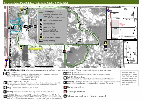
Sacramento NWR has a 6-mile Auto Tour that begins at the Visitor Center and takes you through wetlands, grasslands, vernal pools and a area. Visitors are required to stay in their vehicles but can get out of their vehicles at one of the 3 Park-and-Stretch Areas. A multi-level Observation Deck is located approximately half-way around the Auto Tour in addition to a new low-profile deck, where there is a spotting scope, a restroom, and fantastic views!
Open 7 days a week, year-round, from 1 hour before sunrise to 1 hour after sunset.
An additional 1.5 mile loop called Pool 2 Extension is open from March 15 - September 10, conditions permitting. Pool 2 is drained every 3-5 years to allow for habitat work and road repairs, during which time the extension is closed.
- Parking
- Restrooms
- Information kiosk
- Observation Decks
- Potable water is not available so make sure to bring your own
- Bicycles are permitted on the Auto Tour from May 15 - August 15
- entrance fee
- Download the Map/Brochure (pdf)
Colusa NWR Auto Tour
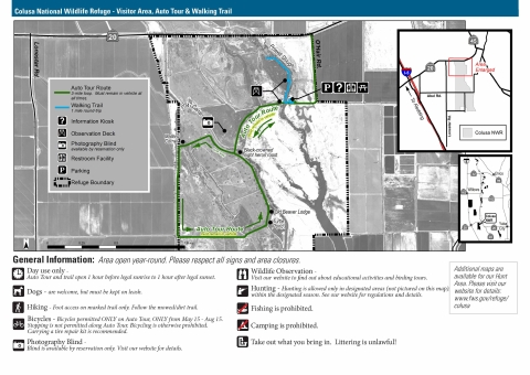
Colusa NWR has a 3-mile Auto Tour that begins at the Observation Deck and takes you through wetlands, grasslands, and a riparian area. Visitors are required to stay inside their vehicles. Look for the black-crowned night heron roost in the button willow as you cross the bridge. Keep an eye open for an occasional collared goose, and also for a western pond turtle in the "turtle pond" located at the very southeast corner of the Auto Tour.
Open 7 days a week, year-round, from 1 hour before sunrise to 1 hour after sunset.
- Parking
- Restroom
- Information kiosk
- Observation Deck
- Potable water is not available so make sure to bring your own
- Bicycles are permitted on the Auto Tour from May 15 - August 15
- no fees
- Download the Map/Brochure (pdf)
Rules of the Auto Tours
- Visitors must stay inside their vehicle except at designated Park-and-Stretch areas. Motorcyclists/bicyclists must remain on their vehicle except at Park-and-Stretch area.
- Visitors must remain seated when their vehicle is in motion. Hanging out of windows and sunroofs is prohibited when vehicle is in motion, but is permissible when vehicle is parked.
- Sitting in the bed of a truck is prohibited except at Park-and-Stretch areas
- Vehicles may not park or travel in the wrong direction
- Speed Limit is 15 mph
- Walking along the Auto Tour is prohibited
- Dogs are permitted but must remain in vehicle, except at Park-and-Stretch areas where they must be on leash
- Bicycles are prohibited except from May 15- August 15. Bicycles are never permitted on the Pool 2 Extension. Dismounting from bicycles is prohibited except at designated Park-and-Stretch areas.
- Drones are prohibited on all USFWS property
- These are citable offenses with fines up to $275.
_____________________________________________________
TRAILS
A variety of trails awaits exploration on the refuges of the Sacramento NWR Complex! Wetlands, grasslands, vernal pools and riparian forests provide different experiences throughout the year. Come explore....
Sacramento NWR
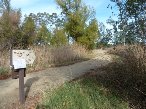
Wetland Walk - These 2-miles of trails depart from the Visitor Center located on Hwy 99W just 6 miles south of the city of Willows. The Wetland Walk will take you through wetlands, vernal pools and riparian habitat. Grab an interpretive booklet (pdf) and learn about the Complex and its wildlife and habitats. The north loop is disabled-accessible.
- Parking
- Restroom
- Information kiosk
- Potable water is not available so make sure to bring your own
- entrance fee
- Download Map/Brochure (pdf)
Seasonal Trails - Open only from February 15 - June 30, this area is accessed from Parking Lot D, on County Road 68. This seasonal area provides up to 6-miles of trails that meander through wetlands and vernal pools.
- Parking
- Restroom
- Information kiosk
- In-ground blinds for photography (waders required)
- Potable water is not available so make sure to bring your own
- no fees
- Download Map/Brochure (pdf)
Colusa NWR
This 1-mile trail (1/2 mile out and back) begins near the Visitor Area located on O'Hair Road, off of Hwy 20 just 2 miles west of the city of Colusa. The trail is a shaded walk through riparian habitat that provides glimpses into the adjacent wetlands. Near the end of the trail is a small boardwalk where visitors can overlook a wetland and catch views of waterfowl. This is a great spot to see wood ducks during the spring and summer. Trail begins near the Observation Deck.
- Parking
- Restroom
- Information kiosk
- Observation Deck and Walkway
- Picnic tables
- Potable water is not available so make sure to bring your own
- no fees
- Download Map/Brochure (pdf)
Llano Seco Unit of the Steve Thompson North Central Valley WMA
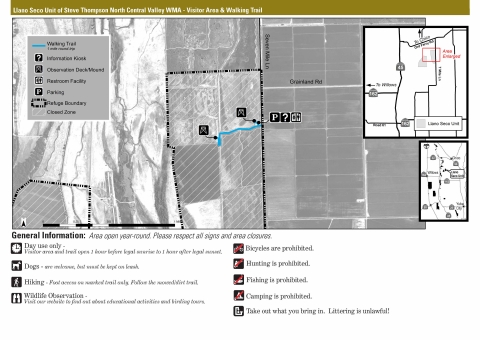
This 1-mile trail (1/2 mile out and back) departs from the Observation Deck at the Visitor Area located on 7-Mile Lane, just 15 minutes southwest of the city of Chico. The trail takes you through the wetlands to an Observation Mound with a picnic table. From October - February you will find great viewing of sandhill cranes and waterfowl. There is very limited shade during the summer.
- Parking
- Restroom
- Information kiosk
- Observation Deck and Mound
- Picnic Table
- Potable water is not available so make sure to bring your own
- no fees
- Download Map/Brochure(pdf)
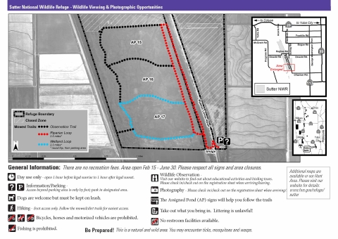
Sutter NWR
Seasonal Trails are only open from February 15 - June 30, and are accessed from Parking Lot B on the Bypass Levee Road (off of Hughes Road), south of the city of Sutter. This seasonal area provides up to 6-miles of trails that go through a long riparian corridor and wander through seasonal wetlands. The riparian section offers great viewing of songbirds and raptors. Waterfowl are present until wetlands dry up in March/April.
- Parking
- Restroom
- Information kiosk
- Potable water is not available so make sure to bring your own
- no fees
- Download Map/Brochure(pdf)
Sacramento River NWR
Visit our Unit Maps and Recreation page to find details, maps and brochures about the units of the Sacramento River NWR. All areas have riparian habitat that offer great viewing of songbirds between March and late May.
- Parking
- Restroom (Sul Norte Unit only)
- Information kiosks
- Potable water is not available so make sure to bring your own
- no fees
- Bicycles permitted on trails from May 15 - August 15, except at Ord Bend
- Some units allow hunting between August 1 - May 31, so check the table on our Unit Maps and Recreation page if you are concerned about user-overlap.
Eight of Sacramento River NWR's units have trails:
- Rio Vista - on South Avenue east of Corning; 6.5 miles of marked trails. Download Map/Brochure(pdf)
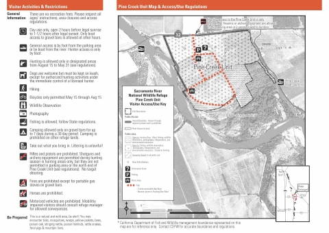
- Pine Creek - on Highway 32 west of Hamilton City; 3 miles of marked trails. Download Map/Brochure(pdf)
- Capay - on Road 23, off of Highway 45 south of Hamilton City; 3 miles of marked trails. Download Map/Brochure(pdf)
- Ord Bend - on Ord Ferry Road just west of Sacramento River; 1 mile of marked trails. Download Map/Brochure(pdf)
- Sul Norte - on Highway 162 west of Butte City; 2.5 miles of marked trails. Download Map/Brochure(pdf)
- Codora - access through the Sul Norte parking area; 4.5 miles of marked trails. Download Map/Brochure(pdf)
- Packer - on Highway 45 north of Princeton; 1.5 miles of marked trails. Download Map/Brochure(pdf)
- Drumheller - on Road 67 southeast of Butte City; 0.4 miles of marked trails. Download Map/Brochure(pdf)
____________________________________________________
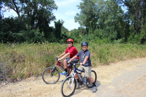
BICYCLING
Bicycling at the Sacramento National Wildlife Refuge Complex is limited to a select number of roads and trails from May 15 - August 15.
When and Where Can I Bicycle?
Sacramento NWR:
Auto Tour - the 6-mile Auto Tour is only open to bicyclists from May 15 - August 15. NOTE: Bicycles are not allowed on the Pool 2 Loop Extension. Only stop in designated park and stretch areas. Please note there is no shade along the Auto Tour.
Sacramento NWR's trails (Wetland Walk, Spring Trails/Logan Creek) and hunt area are not open to bicycles.
Colusa NWR:
Auto Tour - the 2-mile Auto Tour is only open to bicyclists from May 15 - August 15. No stopping along the Auto Tour. Please note there is very limited shade along the Auto Tour.
Colusa NWR's trail and hunt area are not open to bicycles.
Sacramento River NWR:
Seven of the Sacramento River NWR units have trails open for bicycles from May 15 - August 15 (see list below). All brochures and more information can be found on the Sacramento River NWR Unit Maps and Recreation page.
- Rio Vista - on South Avenue east of Corning; 6.5 miles of marked trails
- Pine Creek - on Highway 32 west of Hamilton City; 3 miles of marked trails
- Capay - on Road 23, off of Highway 45 south of Hamilton City; 3 miles of marked trails
- Sul Norte - on Highway 162 west of Butte City; 2.5 miles of marked trails
- Codora - access through the Sul Norte parking area; 4.5 miles of marked trails
- Packer - on Highway 45 north of Princeton; 1.5 miles of marked trails
- Drumheller - on Road 67 southeast of Butte City; 0.4 miles of marked trails
Click here to view and/or download the Complex's Bicycling Map (pdf) to see when and where bicycling is allowed.
Be Prepared! Puncture vine may occur on the edges of gravel roads. You are strongly encouraged to have a can of fix-a-flat or a patch kit suitable for your bicycle's tires, in case something happens while out on the trails or auto tours.
_____________________________________________________
BE ALERT!
These are natural and wild areas. You may encounter ticks, mosquitoes, wasps, yellow-jackets, bees, poison oak, stinging nettle, poison hemlock, rattle snakes (particularly on Sacramento River NWR), and mountain lions. Be aware of your surroundings, hold off on touching plants or insects, and make some noise on the trails, especially if you’re by yourself.
_____________________________________________________
Back to Home Page